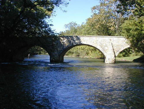
Physical/ Habitat Description - Antietam Creek originates in southern Pennsylvania’s Michaux State Forest. Two smaller branches (East and West) merge just north of the Maryland state line to form the mainstem Antietam. The mainstem is approximately 54 miles in length, with 42 miles existing in Maryland (Washington County, Maryland). The watershed covers 290 square miles and is nestled within the Ridge and Valley physiographic province (“Great Valley”). The creek meanders from North to South, through the city of Hagerstown, Maryland, before reaching the Potomac River in Sharpsburg, Maryland. The mainstem is characterized by karst geological features with a low to moderate gradient, shallow riffles, glides, and slack pools. The streambed consists of boulders, limestone bedrock, and some cobble; but is highly impacted by sediment, nutrification, and erosion due to the surrounding agricultural and urbanization land use.
Fishery - Antietam Creek supports a diverse and unique recreational fishery. Typical of heavily influenced limestone spring creeks, it supports a productive aquatic ecosystem that is capable of growing/supporting trophy fish. Most of the creek is managed as a Put-and-Grow trout fishery maintained by annual stockings of rainbow and brown trout fingerlings. The Maryland Freshwater Fisheries Program hatchery division hatches trout eggs at their Albert Powell Hatchery facility in Hagerstown, Maryland. These fry are reared to several inches in length before being stocked out into the creek. This is a necessary component in providing a “wild” trout fishery due to the limited potential of natural reproduction throughout the creek. Fingerling trout growth in this waterbody is impressive; data indicates growth ranges from 0.5-1 pound per year (0.48-0.96 lbs/year).
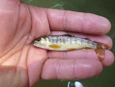

Fingerling brown trout (left) and rainbow trout (right) stocked into the Antietam
as part of the Put-and-grow trout management program.
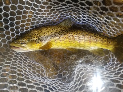

 Anglers should expect a low density but high-quality rainbow and brown trout fishery from the state line to Devils Backbone County Park. Within the park, the 10 foot Devils Backbone Dam, approximately 13.5 miles upstream of the Antietam’s confluence with the Potomac River, restricts upstream movement of fish species. Put-and-Take trout fishing regulations are in effect from the upper boundary of Devils Backbone Park downstream to the mouth of Beaver Creek where stocking of adult brown and rainbow trout occurs annually during the spring and fall. All other areas of Antietam Creek are subject to a 2 trout per day creel limit. Although smallmouth bass are collected throughout the mainstem, the strongest population exists below the Devils Backbone Dam. Other gamefish species that occur in the downstream section (below the dam) are common carp, channel catfish, flathead catfish, walleye, various panfish species, and the occasional muskellunge.
 Access - Apart from Devils Backbone County Park and Antietam National Battlefield, shoreline/wading fishing opportunities are limited. Much of the Antietam flows through private property, which requires landowner permission for access from the banks. The recent development of
“The Antietam Creek Water Trail,” provides soft launch access at various locations throughout the creek and floating the creek has become quite popular among paddlers, tubers, and anglers. Float fishing is probably the best way to experience Antietam Creek when flows are suitable; stretches upstream of Hagerstown are quite difficult to navigate during typical summer flows. Floating from Route 34 in Sharpsburg to the Potomac River is a very popular float and a productive stretch for smallmouth bass.
Access - Apart from Devils Backbone County Park and Antietam National Battlefield, shoreline/wading fishing opportunities are limited. Much of the Antietam flows through private property, which requires landowner permission for access from the banks. The recent development of
“The Antietam Creek Water Trail,” provides soft launch access at various locations throughout the creek and floating the creek has become quite popular among paddlers, tubers, and anglers. Float fishing is probably the best way to experience Antietam Creek when flows are suitable; stretches upstream of Hagerstown are quite difficult to navigate during typical summer flows. Floating from Route 34 in Sharpsburg to the Potomac River is a very popular float and a productive stretch for smallmouth bass.
