 History
The Susquehanna River and Surrounding Area
The Susquehanna River, named for the Susquehannock tribe, is the Chesapeake Bay’s main tributary river, providing nearly half of the Bay’s fresh water. Stretching from New York to Maryland, the Susquehanna’s massive watershed influences the health of ecosystems in both the river valley and the Chesapeake Bay.
For thousands of years, American Indians depended on the Susquehanna River, and built thriving communities and farms along its shores. Their legacy lives on in some of the valley’s place names, such as “Conowingo,” and in the petroglyphs carved into the river’s rocks. Examples of these carvings can be seen in an exhibit at the Rock Run Grist Mill.
After European settlement, the Susquehanna River Valley grew into a prosperous, important center of commerce and industry. Natural resources, such as timber,
coal and farm produce were harvested and shipped. Water-powered mills were built along the valley, bridges were built to join the east bank of the river to the west, and canals (and later railroads and highways) were built along the banks. Major cities such as Harrisburg and Binghamton were also established along the river.
Park History
In the mid-20th century, efforts to conserve the Susquehanna’s ecosystem started to surface. The Maryland Department of Forests and Parks began acquiring land for Susquehanna State Park in the early 1960s, and since then, the park has grown to 2,753 acres. In addition to being a popular destination for hikers, sightseers and anglers, it plays a key role in conserving the Susquehanna Valley’s ecosystem and preserving its heritage.
 Historic Sites
Several historic buildings at Susquehanna State Park have been restored and are open to the public.
Rock Run Historic Area
Follow Rock Run Road to the end where it intersects with Stafford Road. Parking is available next to the mill or behind the Carter-Archer House. A public restroom (open year-round) is located in the carriage barn. There is no fee to visit the historic area.
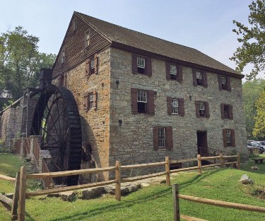
Rock Run Grist Mill
The mill, erected in 1798 by prosperous businessman and landowner John Stump, is a former merchant flour mill. During its most successful years, flour from the
mill was sold to both local and international markets. The three-story stone structure was partially restored in the 1960s, and features a working water wheel and an operational millstone. Corn-grinding demonstrations are held from 1 p.m. to 3 p.m. on weekends and holidays from Memorial Day to Labor Day.
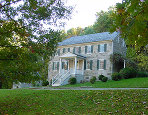
Carter-Archer House
On the hill which overlooks the mill stands the Carter-Archer House. Also known as the Rock Run Mansion, this majestic 14-room stone structure was built in 1804 by John Carter, a partner of John Stump in the Rock Run Mill. When Carter died a year later, the house passed to the Stumps' daughter, Ann, and her husband, Dr. John Archer, Jr. One of their children, James J. Archer, served as a brigadier general in the Confederate Army during the Civil War. Several rooms are restored and furnished with period antiques. Associated with the mansion are a stone carriage barn and a stone springhouse, where the water still runs clear and cold.
Jersey Toll House
Upriver from the mill is a small white frame building known as the Jersey Toll House. The toll house once served a covered bridge that spanned the Susquehanna River from 1817 to 1857. It connected Rock Run with Port Deposit, directly across the river. Several abandoned bridge piers are still visible in the river.
Susquehanna & Tidewater Canal
Between the mill and the river runs a section of the former Susquehanna & Tidewater Canal. Opened in 1836, the canal linked Havre de Grace, Maryland, with
Wrightsville, Pennsylvania. With mule-drawn barges plying its waters, the Susquehanna & Tidewater Canal was a major commercial waterway until it closed in 1894. Two canal locks (one at Lapidum and the other at the mouth of Deer Creek) are located within the park. A railroad line to build and service Conowingo Dam was laid on the towpath in the 1920s. A portion of the the old towpath is now part of the Lower Susquehanna Greenways Trail, which runs from Deer Creek to Conowingo Dam.
Stafford Flint Furnace
Located near the Deer Creek Picnic Area, the Stafford Flint Furnace is a remnant of the once thriving milling community of Stafford. First established in 1748, Stafford at its peak included flint furnace and mill, a merchant flour mill and sawmill. Flint was harvested from nearby quarries, melted down and milled to make porcelain and fine china. The furnace stack is Stafford’s last remaining industrial remnant. The stack is now leaning dangerously, so it is best viewed from a safe distance.
Lapidum
At the lower end of the park is the site of of Lapidum. This settlement traces its history to 1683 with the granting of land patents for the tracts "Paradise," "Elberton" and "Vincent's Castle." As the surrounding land was transformed from wilderness to farmland, Lapidum grew in importance as a commercial center. Corn and tobacco grew along the river bank at Lapidum and a bustling fishing and ice harvesting industry developed here.
Steppingstone Museum
Another attraction to see in the park is the Steppingstone Museum, a private, not for profit museum that preserves and demonstrates the rural arts and crafts of the 1880-1920 period. For more information about Steppingstone, please visit their website at steppingstonemuseum.org or call 410-939-2299.
Steppingstone Museum is located inside Susquehanna State Park near Havre de Grace, Maryland. To get to the museum: Leave I-95 at Exit 89 (Havre de Grace) onto Route 155 north toward Bel Air. After one quarter mile, turn right onto Earlton Road and follow for one half mile. Turn left onto Quaker Bottom Road and follow to the museum entrance, about one mile.
Hours of operation:
The Rock Run Gristmill is open on weekends and holidays from 10 a.m. to 4 p.m., Memorial Day to Labor Day, and upon request.
The Carter-Archer Mansion is also open upon request by appointment only. For more information and updates on the park's historic sites, please contact staff at 410-557-7994.
Directions to the Rock Run Historic Area
Susquehanna State Park is located three miles northwest of Havre de Grace off Route 155 in Harford County. The park is approximately 35 miles north of Baltimore. The Historic Area of the Park is located at 801 Stafford Rd. Havre de Grace, MD 21078
- Take I-95 to Route 155, exit 89. Proceed west on Route 155 to Route 161.
- Turn right on Route 161
- Turn right on Rock Run Road
- Follow Rock Run Road to the intersection of Rock Run Rd. and Wilkinson Rd. (turn right at the Wilkinson dam to stay on Rock Run Rd).
- Continue on Rock Run Rd. until it ends in the Historic Area at the intersection with Stafford Rd.
Parking is available next to the mill or behind the Carter-Archer mansion. A public restroom (open year-round) is located in the carriage barn. There is no fee to visit the historic area.
To Learn More…
Captain John Smith, Chesapeake Bay Program
Kimmel, Ross M., “Susquehanna River Valley Has Long History,” Maryland Department of Natural Resources, 2006
Maryland DNR, “Susquehanna State Park Home to New American Indian Petroglyph Exhibit,” 2016
Maryland Park Service, Self-guided Walking Tour of the Rock-Run Historic Area
Shagena, Jack L., Rock Run Mill in The Land of Promise: A Legacy of John Stump and “Stafford,” 2007.
Shagena, Jack L., Mills: Grist, Saw, Bone, Flint, Fulling…& More: Harford County's Rural Heritage, 2009.
