Healthy waters provide a home where fish and crab flourish, and a lively place where families enjoy themselves by swimming and boating. The decline of water quality (due to excess nutrients, sediments and other pollutants) is one of the main issues affecting the waters and natural resources of the Chesapeake Bay. CBNERR-MD has monitored water quality since 2004 at Otter Point Creek, Jug Bay, and Monie Bay using both, automated continuous monitoring dataloggers (or CONMON stations through SWMP) and through discrete water quality sampling at selected locations.
Objectives
The main objectives of the CBNERR-MD discrete water quality monitoring effort are to:
- Understand the spatial and temporal variability of water quality in tidal freshwater and brackish marsh systems.
- Identify trends and relationships between water quality, land use and climatic changes.
- Promote the use of water quality data for education and stewardship purposes.
Sampling – Where?
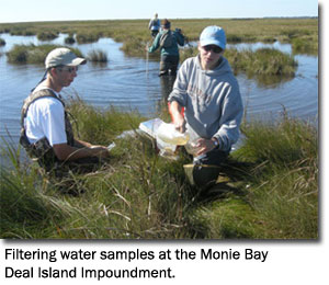
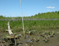
CBNERR-MD samples discrete water quality at Otter Point Creek and Monie Bay once a month from April through October. Otter Point Creek sampling started in 2002 at 6 stations. In 2011 the sampling was reduced to 3 stations due to limited resources. Monie Bay sampling started in 2006 and continues to be measured at 10 stations.
Sampling – What?
Physical-chemical parameters:
|
Nutrients:
|
Water temperature
|
Ammonium (NH4)
|
Dissolved oxygen
|
Nitrite + Nitrate (NO23)
|
Salinity
|
Nitrite (NO2)
|
Total water depth
|
Nitrate (calculated)
|
Secchi depth (measurement of water clarity)
|
Phosphate (PO4)
|
Total suspended solids (TSS)
|
Total nitrogen
|
| Chlorophyll a (indirect measurement of algae in water) |
Total phosphorus |
Where to Find the Data!
- Discrete Water Quality Sampling at Otter Point Creek
- Discrete Water Quality Sampling at Monie Bay
- Contact CBNERR-MD Research Coordinator Patricia Delgado (pdelgado@dnr.state.md.us) or Research Assistant Lindsay Carroll (lcarroll@dnr.state.md.us).
Explore and learn about the interesting research and long-term monitoring projects we are conducting at Otter Point Creek (Bush River), Jug Bay (Patuxent River), and Monie Bay (eastern shore). Our projects range from water quality monitoring to marsh plants to monitoring secretive marsh birds and fish.
We invite you to use our data to support research, modeling, management, and/or education goals. Our data could serve as baseline information to start a new research project, to look for interesting trends, to support modeling efforts, or to complement a project already in progress. We hope our data can help you to make a difference!
Monitoring Climate Change
Stay tuned for this new addition to our website!
Resources
Stay tuned for this new addition to our website!
