MBSS Statewide Sampling Round Four
The Maryland Biological Stream Survey (MBSS) was started by the Maryland Department of Natural Resources in 1993 as a pilot study in three watersheds. It is now a statewide program that has sampled nearly 4000 sites. The third round of statewide random sampling concluded in the summer of 2009. The Fourth Statewide Round of the MBSS will run from 2014 to 2018. Check out the rest of the MBSS web site for more information and to learn more about what MBSS will be doing in the coming years.
Sampling design summary of Round Four
Purpose
The Fourth Round of the MBSS will optimize our ability to detect changes in Maryland’s stream conditions. This will help us to inform management decisions in the future.
Reason
Stream ecosystems are incredibly complex and variable. There is a need to know how they are responding to management efforts in the face of continued impacts. Over the last 20 years the population of Maryland has increased, putting stress on our streams. At the same time, stream restoration activities and conservation (including additional state and local regulations and policies) have increased. Round Four will provide an assessment of how stream ecological conditions have changed which could lead to recommendations on the success of these activities and whether management actions should be adapted to become more effective.
Method
The MBSS uses randomly selected sites to provide a statistically rigorous representation of Maryland's stream conditions. Round Four involves re-sampling a subset of randomly-selected stream sites that were sampled previously, a widely accepted design. This process will take five years. Sites that were sampled in 1995, 1996, and 1997 will be re-sampled 20 years later (in 2015, 2016, and 2017). A separate set of sites that were sampled in 2000, 2001, 2002, 2003, and 2004 will be sampled beginning in 2014 — 14 years later.
Expected Results and Applicability
By 2018 we will have collected sufficient information to compare statewide and river basin estimates of stream condition over 20 and 14 year intervals. We will also have collected sufficient information to compare conditions within select sub-watersheds. For example, Mattawoman Creek will be the first 8-digit watershed where changes will be investigated — all sites that were sampled during 2000 in this watershed will be re-sampled in 2014, thus providing sufficient information to describe stream conditions in 2014 for comparison to conditions in 2000.
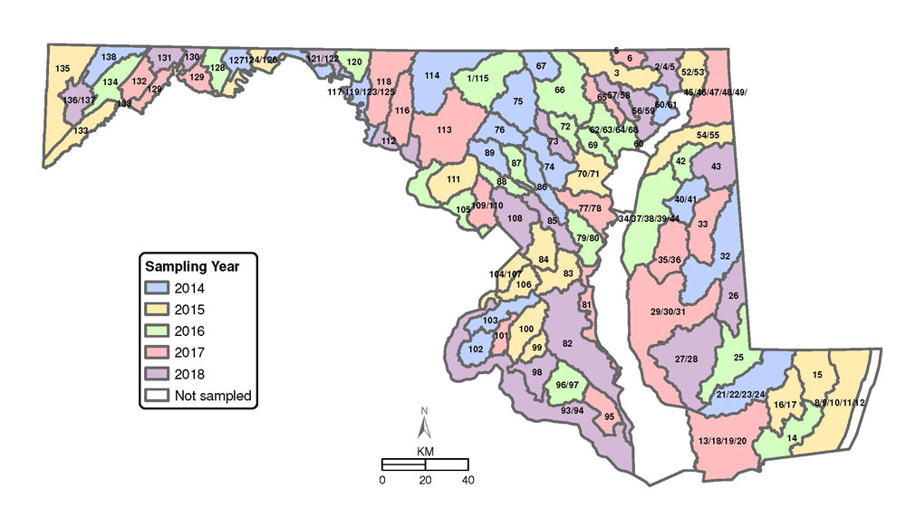
Maps of Watersheds Sampled in Each Year
Round Four sampling will include revists of Round One and Round Two random sites. Because each round used random sampling to characterize the condition of disimilar size watersheds differently, there are two maps needed to describe the sampling schedule. The first map shows when watersheds from Round One will be sampled, and the second shows Round Two. Note that the watersheds are much bigger in the first map. These are considered "Basins" when used by MBSS biologists, but other groups may refer to them as 6-digit watersheds. The watersheds sampled in Round Two are called PSUs (Primary Sampling Units). They are Maryland 8-digit watersheds, with very small ones combined to make the sampling units more uniform in size.
Round One BasinsSampled in Round Four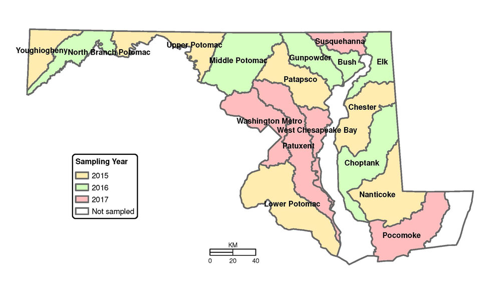
Round Two Watersheds Sampled in Round Four